We had a powder weekend in Mammoth with 3ft Jan20-22 but nothing on the horizon for 10 days. Check Alta, Northwest like Mt Baker or BC and maybe Big Sky.
http://www.cpc.ncep.noaa.gov/products/predictions/814day/814day.02.gif
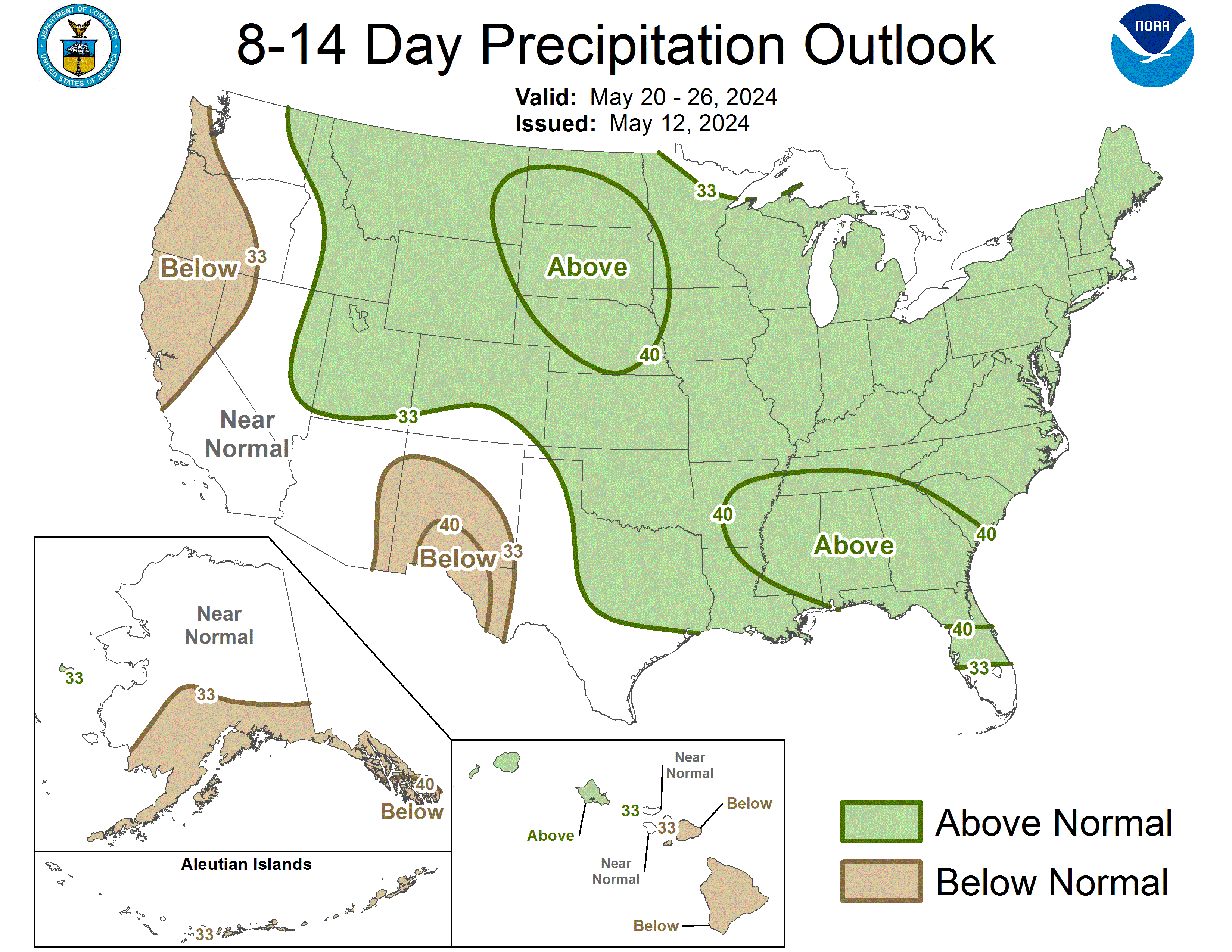
http://weather.unisys.com/gfsx/gfsx.php?inv=0&plot=hght®ion=us&t=5d
http://weather.unisys.com/gfsx/gfsx.php?inv=0&plot=hght®ion=nh&t=7d
—————
The forecasters have turned on the WHITE. Howard Sheckter calls the turn and end of the abysmal sunshine!
San Francisco Weekend Weather – AccuWeather Forecast for CA 94103
NOAA says mid-CAL is at the cusp on through Friday.
————————
December 2010 Alpenhof at Mammoth

No big storms on the horizon. Best chances for snow are northwest and MT.
Maybe some changes in 8-10 days. Austria is the hot ticket and the Euro is 1.27.
Somebody should tell the weathermen(babes) out WEST that warm sunny weather is not what we want to hear. It is the rainy season and we need snow in the mountains because we waste a lot of water in our showers and yards. Moreover it is peak ski season and with the exception of a few resorts in the Northwest it is is the worst season in many years. Montana and Big Sky,Bridger Bowl, Red Lodge had good skiing last week with a couple small dumps but snow is now being vaporized by 60 deg temps.Later this week could be better with some snow showers. Resorts with best base depth are in NW:Mt. Baker, Whistler, etc or if you have a lot of time and money as Euro moves down Austria and Lech-Zurs.Mammoth has not had significant snow since November but has good snow making so there is a base.
Cooling trend but no snow:Weather Geek : TahoeLoco.com
Looking out ten days high pressure dominates the West Coast so no change in this warm, dry pattern is expected.Maybe some techie on the weather scene can explain how LaNina brought this curse upon us.
Scheckter of Mammoth says :”The strato warming event in process is certainly effecting the NH polar regions with the forecasted movement of both PVs. The Dweebs are watching changes that are supported by the GFS ensemble means this morning as well as the ECMWF…
The movement of the large upper low/polar vortex over Alaska back to Eastern Siberia allows for a significant ridge to develop over the Bering sea and Alaska in the 11-15 day period. This ridge builds into Alaska and far Western Canada and also ensures that the vortex over Eastern Siberia can not progress into Alaska. This is a significant change in the pattern to last December. Additionally, the trend in the phase of the AO and NAO is downward toward neutral by mid month. That as compared to the super positive readings of December and November. More later…..
Mammoth Lakes Weather brought to you by Howard Sheckter
If we have any hope it would be late january just from a reversion to mean:
814prcp.new.gif 719×668 pixels
Unisys Weather – GFSx – US – 500mb Hght/SLP – 5day
Surfing is Great!
Well you can always try your luck surfing as Maverick’s has triple 15-18ft overheads